Browse Items (9126 total)
Sort by:
Cooper Nuclear Station

distance photo of Cooper Nuclear Station building in Brownville, Nebraska
Copenhagen Storks:
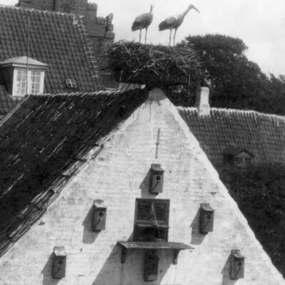
Members of The Nonpareil's European Holiday tour will have the opportunity of seeing these storks when they visit Copenhagen, Denmark, Aug. 12-14. A stork's nest on the house top is the best of good omens. The Nonpareil's tour will leave her July 25…
Corner of Broadway and Pearl

Photograph of street car tracks being layed at the corner of Broadway and Pearl.
Corner of fourth street and fifth avenue

Photograph showing construction at the corner of Fourth street and Fifth avenue, Council Bluffs. Pottawattamie courthouse is in the distance.
Corner of Main and Broadway

Photograph of corner of Main St. and Broadway. Beno's and Buck's Shoes.
Corner of Pearl and Broadway

Photograph of the former Council Bluffs Savings Bank on the corner of Pearl and Broadway.
Corner of Pearl and Broadway

Photographs of the bank building on the southwest corner of Pearl and Broadway.
Corner of Scott St. and Washington Ave.

Four photos of Home Realty on corner of Scott St. and Washington Ave.
Cornerstone Event

The cornerstone of the new $75.000 sanctuary of Walnut Baptist Church is placed in ceremonies Sunday. Participating in the ceremony are the Rev. Dennis DeHaan, pastor; Marvin Sanders of 2837 Avenue J, a charter member, and John Childers of 3229…
Cornerstone In Place

The cornerstone for the new seven-story low rent housing unit was laid Saturday in ceremonies conducted by the Masonic Lodge. Laying the cornerstone are Lorenzo Sewell, Master of Missouri Valley Lodge 232; Otto Christiansen of Missouri Valley;…
Cornerstone Laying Ceremony Is Sunday - $350,000 Plant

Admiring Stone . . . to be placed in the corner of the Educational Unit at First Christian Church are Mrs. Wilbur Hummel, Richard D. Hogan, pastor, and David Peterson.
Cornerstone Taken From Fire Station

Fire Chief Norman Elgan . . . looks on as Mayor Donald Franksen and Councilman Joseph B. Katelman hammer away to free a granite cornerstone erected in 1909 at the old Central Fire Station. The cornerstone will be placed in storage until the new…
Cornerstone, Dedication Ceremonies Sunday At Carter Lake's New United Presbyterian Church

Buff Brick Exterior...of Community United Presbyterian Church will be complimented by landscaping and shrubbery.
Cornerstone, Dedication Ceremonies Sunday At Carter Lake's New United Presbyterian Church

Admiring Sanctuary...of new structure is Rev. Walter G. Millett
Corning unveils statue
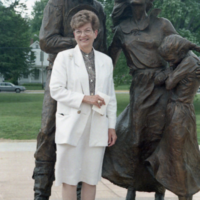
Lt. Gov. Joy Corning, in Council Bluffs Saturday to unveil the statue "Family, an Everlasting Heritage", by Bill L Hill, a noted western artist, said the bronze, located in the viewing garden of the Mormon Tabernacle, "captures the spirit of Iowa…
Coronary Care-Intensive Care Unit At J.E. Has Open House

Nurses Monitoring Station . . . of new coronary care unit at Jennie Edmundson Hospital is checked by Dr. Nosrat Massih, director, with Mis Lois Gordon, RN, area supervisor at left, and Miss Vasthi Christensen, RN, coordinator of coronary care and…
Corps Saves Baby Buffalo

Trapped In Botna Bend Park At Hancock...when the West Nishnabotna River went over its banks were the baby buffafo, Dimples, his mother, Daisy, and stepfather, Dave. The buffaloes and the park elks were forced to stand on high ground for nearly 36…
Corridor Plans Are Displayed

Washington Avenue Corridor plans are discussed by the Rev. Richard Hogan, pastor of First Christian Church which may be affected by the highway relocation, and J. Frederic Schlott, vice chairman of the city's Parks and Recreation Department. The…