Browse Items (9056 total)
Sort by:
De Soto Nat'l Wildlife Refuge #1

Sign says "Leaving DeSoto National Wildlife Refuge."
De Soto Nat'l Wildlife Refuge #1

De Soto Lake
De Smet's map of the Council Bluffs

Likeness of De Smet's map of the Council Bluffs, Iowa area, 1839. De Smet's mission is labeled "St. Joseph's", The area labeled 'Caldwell's Camp' was a Potawatomi village led by Sauganash; this was at or near the later town of Kanesville, the…
De Giorgi Bros postcards

Two postcards of the De Giorgi Bros seed company.
De Forest Wireless Tower

De Forest Wireless Tower, St. Louis Exposistion, 1904.
De Forest stock certificates

2 photographs of American De Forest Wireless Telegraph Company.
De Forest 'Proud' New School Bears His Name; Westside Structure Dedicated To

Admiring Portrait...of Lee de Forest are Miss Doris Killins, Mrs. William Dague and C. Francis Putnam.
Days Of Labor Are Over For Annie's Aged Team

Driving Home . . . from trading at the corner grocery is Mrs. Annie Nelson, standing with the reins instead of sitting in her ice cream chair.
David DeVol House

Photograph of David DeVol House. 114 South 1st street. Mr. and Mrs. David DeVol and Mary DeVol are standing in front of the house.
Danish Hall

Corner of Pierce St. and Park Ave
Dance Ticket

Ticket for a dance at the Kursaal Dance Hall at Lake Manawa.

Dance Hall at Lake Manawa

Photograph of dance hall at Lake Manawa.
On back of photo: "Richard Reynold age 10 Underwood"
On back of photo: "Richard Reynold age 10 Underwood"
Dams: $26 Million Industry - Richter Stresses Recreation Need
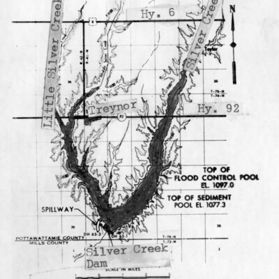
(top) Silver Creek Dam . . . south of Treynor would provide a reservoir with 2,400 surface-acres of water, if approved by the Board of Review for Rivers and Harbors in Washington, D.C.
(bottom) Graybill Creek . . . near Macedonia would be…
(bottom) Graybill Creek . . . near Macedonia would be…
Daley named office of resource group

Patrick Daley
[HR manager at Blue Star Foods]
[HR manager at Blue Star Foods]
Dainty Antique Etagere Graces Dodge Front Hall

Unbelievable Beauty...is created by the contrast of the ebony black finish of the etagere in the front hall of the Historic General Dodge House and the mother-of-pearl embellishments. Mrs. Michael Terry, guide, "It is easily moveable on its tiny…
Dainty Antique Etagere Graces Dodge Front Hall

Unbelievable Beauty . . . is created by the contrast of the ebony black finish of the etagere in the front hall of the Historic General Dodge House and the mother-of-pearl embellishments. Mrs. Michael Terry, guide, said "It is easily moveable on its…
Daily Ritual At Berg Home Funny--But Nobody Laughed

Squirrels Dine...in deluxe accommodations, serviced by Berg.