Browse Items (6175 total)
- Collection: Council Bluffs Daily Nonpareil Archives
Sort by:
Mondamin Plans New Library - 'Something We Need'

Entering . . . the Mondamin Public Library is Mayor Jerry Shelton. The library has been located in the town's municipal building for over 50 years, but has outgrown its space.
Mondamin's Hotel Full Of Memories - But Not Very Many Paying Guests - Salesmen Don't Stay In "The Sticks" Now

Raking Yard . . . around Mondamin's hotel, a 10-room house, is Mrs. Kate Deith and her dog, Barry
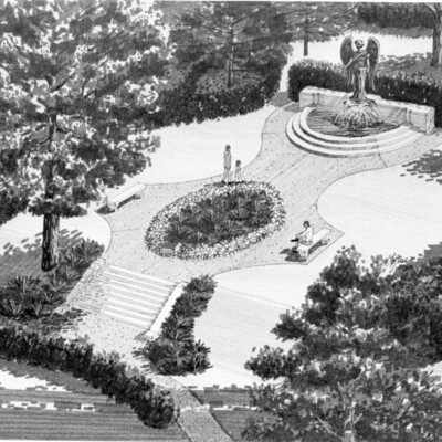
Money Flowing In As 'Black Angel' Work Continues

Above is an artist's rendering of the Ruth Anne Dodge Memorial upon completion of restoration work.
Money flowing in as 'Black Angel' work continues
Above is an artist's rendering of the Ruth Anne Dodge Memorial upon completion of restoration work.
Monument At Earling Home

A large colorful monument to the Blessed Mother Mary stands on a hill overlooking Earling. The monument, in front of the Little Flower Haven Nursing Home, was constructed by Msgr. N.A. Gaul, 81, a resident at the home. The curved structure, of…
Monument Faces Testing Before Restoration Work

Moisture seeping into the Lewis and Clark Monument is blamed for extensive damage to the reliefs. A committee working to restore the monument hired a contractor Thursday to conduct tests to determine how the work should proceed.
Monument Is Crumbling

Signs of deterioration are showing on portions of the Lewis and Clark monument as pointed out by Terry Cox, city recreation superintendent. Weather is the apparent culprit. The upper corner of the west side of the monument, one of the favorite…
Monument Restoration Nearing Second Phase

Panels on the Lewis and Clark Monument have deteriorated.
Monument To Brave Colonel Kinsman

Kinsman's Monument In Fairview Cemetery
MOOOOve This Cage

MOOOOve This Cage...off of me, bawls one of the cattle trapped under the overturned truck. Three were killed.
[Photo zoomed-in view of Best_Pictures_Best_Stories_1959_05_6_1959_11.jpg]
[Photo zoomed-in view of Best_Pictures_Best_Stories_1959_05_6_1959_11.jpg]
Moose To Face No Charges Over Pickles

The Moose Lodge, 807 S. 21st St. Authorities say they won't prosecute sale of illegal pickle tickets.
Mopping Up:

Firemen water down the remains of the second floor of the old Howard Plastics building, 1401 S. Main St., after it was gutted by fire Saturday. Samual Bittner, owner of the building, was not available for an estimation of the loss. Fire Chief Waldo…
Moran Named To Jepsen Staff

Mike Moran
More Showers

Hiding From Rain...that began falling while they played in Bayliss Park are Dianne, 7; Brant, 6-1/2, and Nancy, 9, all children of Dr. and Mrs. Charles R. Noziska, 125 Third St. Their dog, Hedy, squeezed in under the park bench, too.
More Than 50 Hikers On Trek To Mo. Valley, Back

With Aid Of Walking Sticks...Fireman Robert Carroll, an unidentified man, and Policemen C.E. Moore, Ronald Stevens, John Schweer, Herbert Mace and William Lane continue on their long trek to Missouri Valley and Back [sic].