Browse Items (9140 total)
Sort by:
City Hotel

Photograph of the City Hotel on Broadway, with people on the porch and deck.
City Is Waging Annual Battle Against Leaves; 'State Of Emergency'

Pool Of Rainwater...makes a pretty mirror for St. John's Lutheran Church at Willow Avenue and Seventh Street. The underlying cause was a leaf-choked culvert.
City Manager Makes Things Happen Here

Staff Meetings . . . each Monday morning is how City Manager Don Harmon starts off the week. Harmon, at head of table in top center, feels that inflation is one of the biggest problems facing Council Bluffs city government. Some needed services have…
City Manager Plan

[on back of photo:
"First Meeting under city manager system. April 3, 1950"
"First Meeting under city manager system. April 3, 1950"
City Manager Plan Pin-Points Authority; Just Like Any Well Run Business Organization

One Line of Authority...pinpoints responsibility under the Council-Manager form of government. Voters elect a Council. The Council hires a manager. The manager runs the city.
City Manager Plan Pin-Points Authority; Just Like Any Well Run Business Organization

Divided Control...reaches a peak under Mayor-Council government. Each ward picks its representative. The representative joins his counterparts in a nine-way control of the city.
City Mills and No. 3 Engine House

Photograph of City Mills in Council Bluffs
City National Bank
Our "Friendly" Bank

Since 1909, the City National Bank has encouraged the development of this community and aided by financing farmers, merchants and manufacturers in Council Bluffs and Southwestern Iowa. Each day all the facilities of this Bank have been available to…
City National Bank Open New TV Drive-Up Facility

Money-Studded Ribbon . . . is cut by Miss Council Bluffs to open the drive-up TV banking service at City National Bank. Assisting with the ribbon cutting are Robert Turner, chairman of the board, and Roland Tornblom, president.
City Official Says Don't Can It, Bag It - October Start For MBR

Maps of Four Areas . . . selected for the Mechanical Bag Retriever (MBR) pilot program of garbage collection also show on which days collections will be made. Residents of these areas will be receiving free plastic bags on Sept. 10, enough for three…
City Orders James Block Demolished - Must Be Vacated By July 10

Demolition Order . . . applies to this three-story structure in downtown Council Bluffs, a landmark dating back to Civil War times.
City Planning Commission Spends Only $378; Members Assist in Community Development!

Planning Engineer S. Herbert Hare presents Master Development Plan to Commission Chairman Henry K. Peterson

City ponders 'welcome sign' to the Bluffs
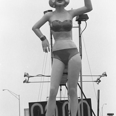
A matter of differing tastes... has put this figure in the middle of the debate. Others like her, however have appeared in other locations in Council Bluffs before.

City Reins Given Hoden - Wins By 3-2 Vote

Taking The Oath Of Office . . . from City Clerk Elmer Westphal Saturday is Mayor Ben Hoden who was elected by other city councilmen to the one-year post. Past Mayor John Pogge was elected mayor pro tem.
City Roller Mills, 1875

Photograph of the Council Bluffs City Mills building, J. C Hoffmayr proprietor. A brief history of the mill is on the back of the photograph.
City Roller Mills, 1881

Photograph of the City Roller Mills, 1881. Brief history of the mill appears on the back of the photograph.
City Roller Mills, circa 1890

Photograph of Old City Roller Mill at Washington Ave. and Bryant. Picture taken about 1897. Features three people in a cart pulled by a donkey. Driver is Miss Cora Hitchcock, now Mrs. C. B. Matthai of Omaha and Miss May Snyder. This mill was built in…