Browse Items (9099 total)
Sort by:
Gov. Ray Attends AAU Tournament

Gov. And Mrs. Robert Ray . . .enjoy an evening of basketball Wednesday at the AAU tournament here. Ray welcomed the teams to Iowa and said he looked forward to having them back next year. "We're proud of girls; basketball and Iowa is the leading…
Gov. Ray To Attend T.J.'s 50th Jubilee

Janet Wray, Thomas Jefferson Senior...puts finishing touches on the Yellow Jacket, while drama instructor Reuben H. Fanders gives helpful hints. The Yellow Jackets mascot will join the letters TJHS and the school's seal on a curtain to overshadow…
Gov. Ray Tours SWI Drought Area
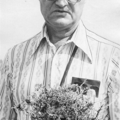
A stalk of Corn...showing rootworm damage is held by Jay West, area crop production specialist at Iowa State. The problem is one of several plaguing Coomes' crop at Atlantic.
Gov. Ray Tours SWI Drought Area - Asks Disaster Designation

A Stalk Of Corn . . . showing rootworm damage is held by Jay West, area crop production specialist at Iowa State. The problem is one of several plaguing (Jim) Coomes' corn crop at Atlantic.
Governor Sees The Danger

Atop the sand-bagged, dirt bulwarked levee, which held the crest of the Missouri river flood waters away from Council Bluffs are, left to right, Mayor S.W. McCall, Lt. Gen. M.A. Tinley, commander of the Iowa state guard; Gov. B.B. Hickenlooper of Des…
Governor's Coffee

Gov. and Mrs. Leo Hoegh entertained the Iowa legislators at coffee in the governor's mansion at Des Moines Wednesday afternoon. The governor and Mrs. Hoegh and their two young children are shown bidding farewell to two of the guests, Rep. and Mrs.…
Grace Church Celebrating Its Roots

The Rev. J William Brewer, pastor of Grace Presbyterian Church, is standing in front of the new sign that identifies his congregation. The church is celebrating its centennial with a series of services and rejoicing its past history and…
Grace Presbyterian Church

Photograph of the exterior of Grace Presbyterian Church with daily vacation Bible School children in foreground.
Grace Presbyterian Church

Grace Presbyterian Church
214 East Pierce, Council Bluffs, IA
214 East Pierce, Council Bluffs, IA
Grace Presbyterian Church

The Grace Presbyterian Church . . . located at Grace and East Pierce Streets. It was formerly . . .
A One Room Building . . . know as the Second Presbyterian church. The name was changed in 1924.
A One Room Building . . . know as the Second Presbyterian church. The name was changed in 1924.
Grading Begins On Interstate 80; Construction Resumes After 5 Years - 'It's A Barrier' to Farmer . . .

End Of Line . . . for the moment on westbound Interstate 80 is a quarter mile west of Highway 71, north of Atlantic. Paving reached this point in 1959.
Grading Begins On Interstate 80; Construction Resumes After 5 Years - 'It's A Barrier' to Farmer . . .

Grading Began . . . last week south of Elk Horn to finally start westward extension of Interstate 80 toward the Missouri River.
Grafitti A Big Deal To Gangs

The base of the West Broadway viaduct is a favored 'canvas' for gang graffiti.

Grand Hotel

Grand Hotel, before 1925 fire
Grand Hotel

Postcard of the Grand Hotel, Council Bluffs, Iowa.
Grand Hotel

Postcard of the Grand Hotel in Council Bluffs, Iowa.
Grand Hotel

Postcard of the Grand Hotel Council Bluffs